
We had planned a trip to Yellowstone National Park and to get there, we decided to drive. This took us through South Dakota in the upper Great Plains region of the United States. Divided in two by the Missouri River, it is famously home to the Black Hills, Mount Rushmore and the Crazy Horse Memorial.
I love road trips. Actually, what I mean to say is, I love travel and my favorite form of travel is…road trips. If you do too, explore these 10 iconic U.S. road trips.
Don’t get me wrong, when you need to get somewhere and there is a short time to do it, a plane is mighty handy. And, of course, a car won’t take you on a cruise.
But for me, spreading that atlas (an antiquated book of maps) on the kitchen table to determine our route to…wherever, is exciting.
The Freedom of Road Trips
There’s something liberating about setting out on the open road. Setting your own course but able to detour at will and chase down some unexpected adventure. Or to simply pull over for a picnic lunch at the time of your choosing, surrounded by a new, unknown beauty.
Blame it on youthful family car vacations. As children, we were well aware of the destination. However, we had little, if any, idea of how we were getting there. So, with windows down for the only cooling breeze the old Chevy had, we sat in the back seat and watched the world go by.
Each new bend in the road, every rising hill, and especially every billboard brought some new sight or possible new adventure. At the very least, some new agenda presented, pleadingly, to the parents.
The fact that you are able, on a whim, to recreate a schedule is freedom in and of itself. Sure, the drive is a means to an end, that final stop. But it’s those wonderful, impulsive detours that can truly enhance, well, a road trip.
That was the real thrill: unlocking a new, unknown experience a mile at a time.
Detours On South Dakota I-90
A planned trip to Wyoming had us crossing the breadth of South Dakota.
Although South Dakota’s portion of Interstate 90 is a superhighway, surprisingly, it’s one of those routes that lends itself to exploration and impulsive adventures.
It cuts across the prairie that stretches nonstop to the horizon, dotted with cheesy roadside stops. Along the way are a couple of National Parks, historic landmarks, and small-town charm that make Interstate 90 one of the most popular road trips across South Dakota.
Exploring Sioux Falls
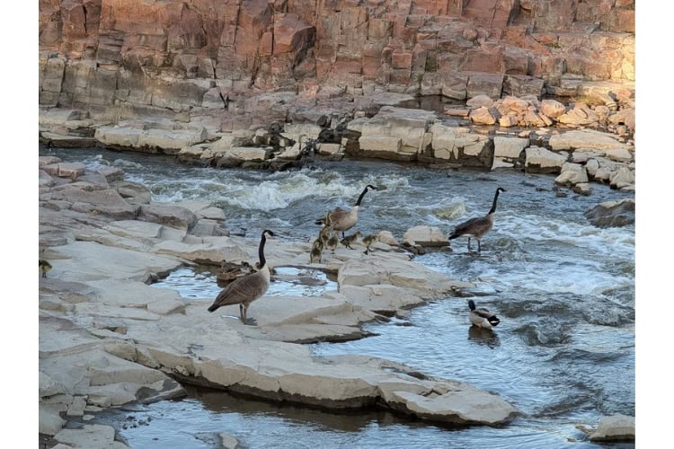
The feathery family of Canada geese approached the rushing water tepidly. The streaming river was not overly deep. But as it coursed through the shallow canyon, it cascaded over stair-stepped falls, picking up considerable speed. The parents took turns crossing the rushing waters with some difficulty.
The goslings’ heads bobbed up and down as they appeared to hesitate. Then, one by one, they plunged into the waters and quickly disappeared behind a boulder, swept away with the current.
Several onlookers, including my wife Kathy, let out a gasp while the parents seemed perplexed, hesitatingly walking the bank in search of their family.
Suddenly, each chick began popping up and scrambling onto the far bank. Everyone sighed with relief.
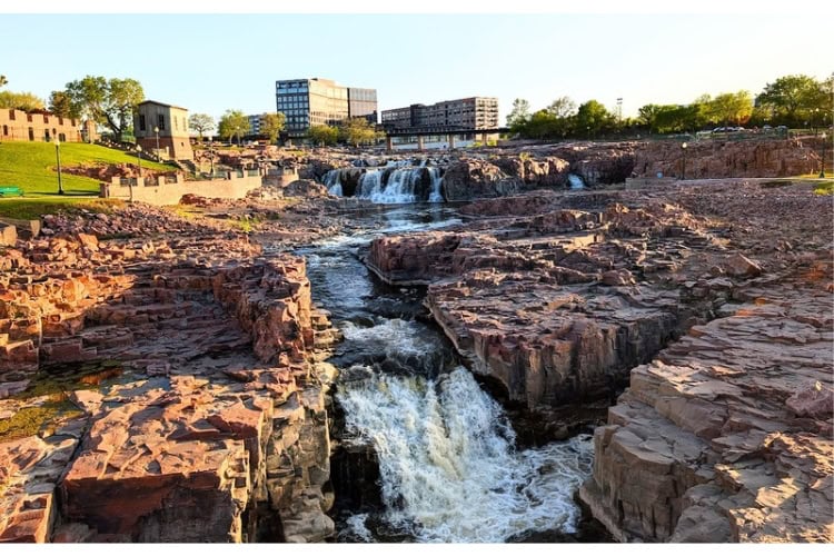
We were standing in the basin of Falls Park, located north of downtown Sioux Falls, our jump-off for our trip west through South Dakota. The park covers 128 acres along the Big Sioux River.
An average of 7,400 gallons of water drops 100 feet a second over the course of the falls, highlighting the beauty of the pink and red quartzite rock it flows through.
History Across the River
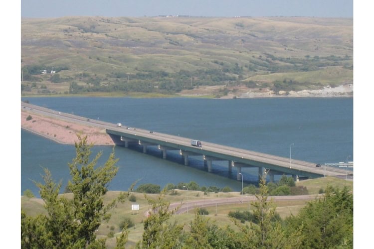
On the east side of the river, there’s also a bit of history to enjoy. The Falls Overlook Café occupies what used to be the Sioux Falls Light & Power building, which was built in 1908.
Then there are the ruins of the once-impressive Queen Bee Mill. When completed in 1881, it stood over six stories above the nearby river. Unfortunately, a fire engulfed the building in 1956, leaving the remains that are seen today.
The nearby Steel District, anchored by the Canopy by Hilton where we were staying, is the newest addition to Sioux Falls’ downtown. Located on the banks of the Big Sioux River, it was built on the former site of the Sioux Steel factory.
Monks Ale House, billed as the original craft beer bar in the state, with its brick walls, empty beer cans and neon light décor, provided an easygoing end to the day with pizza and brew.
Mitchell’s Palace Of Corn
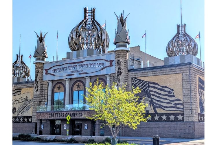
It’s 8:00 AM. The streets are fairly quiet save for a few workday motorists and a dog-walker. I’m gazing upon a most interesting building in the heart of Mitchell. A two-block-long brick-based building topped with aluminum Russian Orthodox-style onion domes and Moorish minarets.
Surprisingly, that is not its most distinctive feature. The façade is filled with images celebrating the Semiquincentennial (250th) birthday of America. However, it’s the medium that’s unique. The wall’s murals come to life with corn, grain and grass all adhered to the face of this multi-purpose arena.
Originally built as a way to promote South Dakota’s healthy agricultural climate and to host the annual Corn Palace Festival. Each year, ear by ear, the corn is nailed to the Corn Palace to create all-new scenes.
Inside, we found exhibits telling the story of the place and a gift shop with quite a few corn-based gifts and foods that Kathy took advantage of.
Dignity: Of Earth & Sky
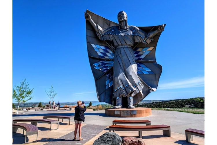
Approaching the bluffs that rise above the Missouri River, the mid-morning sun shone upon a towering form that commanded our attention.
Located at the Chamberlain Welcome Center and Rest Stop, the stainless-steel, 50-foot-tall statue of a Native American woman honors the cultures of the Lakota and Dakota people. Her arms are outstretched with her hands grasping a star quilt decorated with diamonds of various shades of blue that glitter in the sun.
Just yards from Dignity, overlooking the majestic Missouri River, lies the captivating Lewis and Clark Interpretive Center.
On their journey up the Missouri River, the Corps of Discovery set up a campsite nearby called “Camp Pleasant” in September 1804. The Center celebrates their passage.
I wandered past interactive displays and storyboards that help to bring to life their awe-inspiring expedition, which helped to shape the course of American history.
The expedition had its first meetings with the Sioux nearby. Lewis and Clark’s journey was successful, in part, because of help received from Native Americans.
Minuteman Missile National Historic Site
I grew up in an era of once-a-month “duck-and-cover” drills. As schoolchildren, we were trained to drop to the ground, crawl under a desk or sturdy object, and tightly cover our necks and faces to protect against nuclear blasts and flying debris.
In hindsight, it was laughable, except that it was a deadly serious business. The Cold War was an all-encompassing part of our lives in the last half of the 20th century. It led to fear, panic and distrust, made all the more real by a nuclear arms race between the United States and the Soviet Union.
Below me, through glass that has been welded onto the 110-ton hatch of an 80’ silo beneath the prairie grass, the business end of a Minuteman Missile stares back at me, bearing a 1.2 megaton nuclear warhead. Deactivated, I hope.
The Delta-09 Missile Silo National Historic Site, which is unmanned, is located about half a mile south of the I-90 Exit 116 interchange on a gravel access road past forbidding signs warning of rattlesnakes.
Hidden in plain sight beneath the western plains, for thirty years 1,000 missiles were kept on constant alert; hundreds remain today.
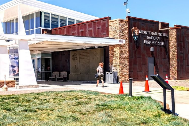
Roughly 9 miles south on I-90, the Minuteman Missile Visitor Center, manned by several rangers and volunteers, sits on a grassy overlook that belies the story it tells. Inside, exhibits share stories and the horrors of the nuclear arms race. It still frightens how close the human race has come to total destruction.
Badlands National Park
Onward we drove past a Stonehenge created from fire trucks, a giant brontosaurus, a very large concrete prairie dog, cattle farms and endless grasslands dotted with cattle.
And then, the landscape changed.
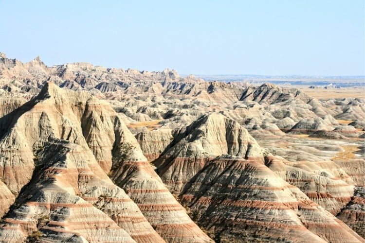
Red-streaked buttes, knife-edged ridges, deeply carved gullies made up of dark shale, white sandstone and richly colored volcanic ash, Badlands National Park is an otherworldly land that cuts through South Dakota’s grasslands.
Taking Exit 110 near Wall, SD, we entered the Badlands Loop Scenic Byway, which took us through twisting curves that rose up to and over passes in the wall of beautifully ugly, rugged rock pinnacles.
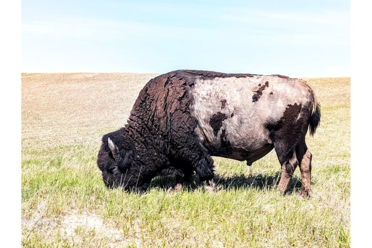
In a land that looks completely uninhabitable, it was surprising how much life we saw: pronghorn antelope, bighorn sheep and American bison. One such behemoth stood so rigidly still near the Pinnacles Overlook parking lot that my wife thought he was a statue. That is, until his tail twitched, catching her completely unawares and a little too close for comfort.
There are 12 designated roadside scenic overlooks to take in the nearly indescribable sights and vast, striking, colorful landscapes that might make you think you’re on another planet. If you plan to hop out for overlooks or short trails, brush up on pro hiking tips to stay safe in summer.
As we left the unforgiving maze of canyons and stark crests, I understood better why the Lakota Sioux called this region “mako sica,” which means “bad lands.”
For those who want the history and geology behind each stop without slowing the pace of their own drive, a self-guided audio driving tour of Badlands National Park narrates the overlooks in real time, so the detours stay just as spontaneous.
A Drug Store That Draws Tourists
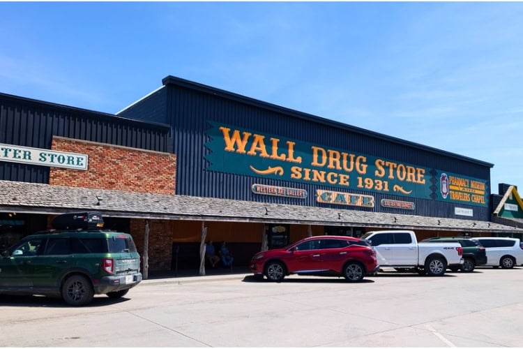
We began seeing the colorful hand-painted signs: Free Ice Water, 5-cent Coffee, Homemade Donuts, all followed by two words, Wall Drug, hundreds of miles before we ever found the origin.
Wall, South Dakota, has 700 residents; however, its drugstore is visited by 2 million people a year. Wall Drug, which is a functioning pharmacy, may very well be South Dakota’s largest non-government-supported tourist attraction.
Opened by Ted Hustead and his wife Dorothy at a time when roadways were bereft of rest stops and filling stations, they lured tourists on their way to parts beyond with signs offering free ice water…lots of signs.
Wall, South Dakota
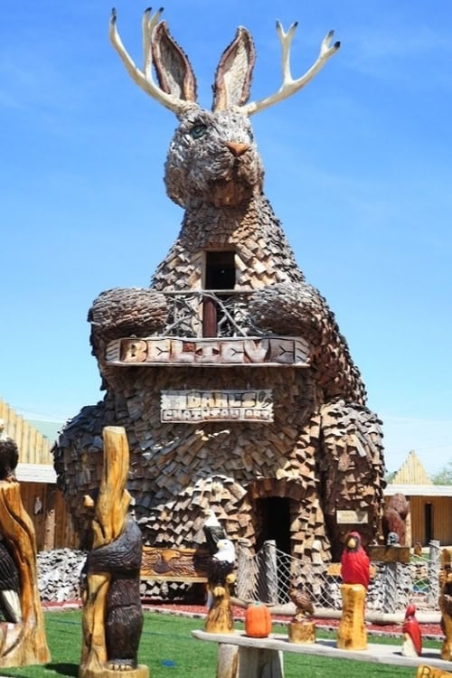
We drove into Wall, past the largest wooden jack-a-lope I’d ever seen, to Main Street where buses, cars, pickup trucks and dozens of motorcycles crowded the street and several surrounding parking lots.
Since 1931, Wall Drug has evolved into a 76,000-square-foot wonderland of free attractions, a kitschy western-themed department store, museum, and the Western Art Gallery Restaurant, which seats 520 and serves 5-cent coffee and freshly made donuts. Oh, and the ice water is still free.
There’s also an art museum, Black Hills Gold jewelry counter, bookstore and even a Traveler’s Chapel.
As I wandered through the aisles and connected buildings, I embraced the aura and wackiness of Wall Drug, and, it appeared to me, so did the others.
I saw a feeling of relief and, dare I say, enjoyment on people’s road-weary faces. Maybe they were just stretching their legs, but it sure seemed that all were fully embracing the experience.
Rapid City And Beyond
350 miles later, I-90 took us into and through Rapid City, South Dakota’s second-largest city. It lies just east of the Black Hills National Forest and is the gateway city to Mount Rushmore, the Crazy Horse Memorial and Custer State Park, all major attractions of South Dakota’s Black Hills and a story in and of itself.
Did I mention I love road trips? I love discovering unique, unplanned and interesting roadside attractions. They’re perfect for working the kinks out and taking a break from a long drive.
South Dakota’s serendipitous detours create memories you didn’t know you needed.
If You Go
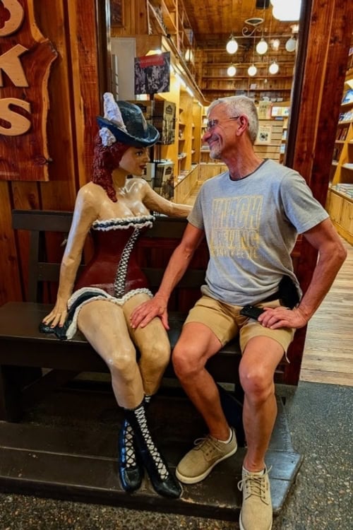
Photo by Kathy Hosek
Getting There
Interstate 90 is the longest interstate highway in South Dakota, with 413 miles through the state, beginning in Sioux Falls on the Minnesota border and ending in Spearfish before continuing into Wyoming.
Where to Stay
In Sioux Falls, settle in at the Canopy by Hilton Sioux Falls Downtown, a stylish stay on the banks of the Big Sioux River just steps from Falls Park. Book a stay at Canopy by Hilton Sioux Falls Downtown on Expedia
Need a hand planning your trip? Here are the sites and services we rely on most, from booking tools to travel products we love.
Inspire your next adventure with our articles below:
- A Day in Grand Teton National Park: Mormon Row, Jenny Lake and the Views That Stop You Cold
- Hidden Gems in the American West: Road Tripping Through Canyon Country
Author Bio: Frank Hosek relishes traveling with his wife, Kathy. He enjoys discovering new experiences, meeting the people that make those experiences memorable, and sharing their adventures with others. He has written for Go World Travel Magazine, The Daily Journal, News Gazette and Lifestyles magazine. Frank has won awards from NWPA and IWPA for his travel writing. He looks toward the horizon for the next adventure.
Want to discover more hidden gems and helpful travel tips? Join our free newsletter for the latest travel secrets and travel articles.
We are reader-supported and may earn a commission on purchases made through links in this article.

- A Swiss Village, Lakeside Mansions and Door County Bluffs: Fall in Wisconsin - October 3, 2026
- The Sleeping Bear Dunes: Discovering the Splendor of Michigan’s National Lakeshore - September 24, 2026
- A Day On Tybee Island: 5 Things To Do When Exploring Savannah’s Beach - September 22, 2026
Planning another trip soon? ✈️
Add GoWorldTravel.com as a preferred source on Google. Click the button below so our local guides, packing hacks, and hidden-gem itineraries always show up first when you search!
Add to Preferred Sources