
“Have you seen the French woman?” the man in a white pickup truck asked expectantly. I was surprised to see a vehicle on this closed portion of the Denali National Park Road.
Then I noticed the name of one of the posh resorts near the end of the road painted on the side of the truck. The resorts had a few vehicles trapped beyond the Pretty Rocks landslide that had closed the road beyond mile 43.
“No, I haven’t seen her,” I replied, “but I’ve heard about her.” All cyclists on this 45-mile stretch of closed road knew about each other – there were so few of us who had trekked around the landslide, lugging a bicycle along.
“Is she missing?” I asked, noting his disappointment that I was not she.
“Yes, she went the wrong way,” the man said. “The ranger asked us to look for her.”
My encounter with the pickup truck was in the middle of my 1,300-mile, summertime bicycle tour of Alaska.
As a 65-year-old woman cycling solo and self-supported, I was a curiosity that frequently prompted people to first ask if I was traveling alone, and then toss etiquette aside and ask my age.
Exploring Denali’s Wilderness
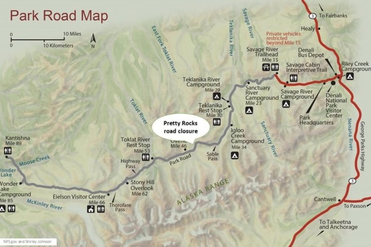
Denali National Park in interior Alaska has a single, dead-end 92-mile road within six million acres of wilderness. Private automobiles are allowed to mile 15.
Then, the road turns to gravel, and only park buses are allowed to make a turnaround at mile 43. Beyond mile 43, the road was closed in August 2021 due to the Pretty Rocks landslide caused by melting permafrost.
I arrived at the park just before 6 PM. A ranger told me bicycles could get around the landslide, but I’d need a permit from the wilderness center.
It was too late to go to the wilderness center, so I inquired whether there were any campgrounds that were tent-only (no RVs) and no campfires. Yes! Sanctuary River Campground at mile 23 of the park road.
“No problem,” I thought. “I’ll just zoom back there.”
Little did I know that the park road starts with a nine-mile hill with some 10% grade. Not quite what I was expecting at the end of the day, but beautiful nonetheless.
Park buses stop running at 10 PM, so I had the road to myself after that. It was gorgeous, with the sun lighting up the mountains across the valley like floodlights on a movie set. I arrived at the campground around 11:30 PM, still bright daylight.
Denali National Park Tours & Excursions
The Landslide Challenge
The next day, I rode from the campground to mile 43 to assess the situation.
Circumventing the slide would involve dropping down to the riverbed, multiple river crossings, and then climbing back up to the road after about five miles at a point where the road descends somewhat. Here’s the kicker: there is no trail.
As I rode back to the park entrance, I pondered whether I could make it around the slide alone, pushing my heavy touring bike.
I asked myself a series of ‘what ifs.’ What if I get lost? What if I twist my ankle? What if a wild animal attacks me? There is no cell phone service. I could die.
Yet here I was at Denali National Park when a landslide had closed 45 miles of park road. Biking the closed road was an opportunity that I couldn’t pass up. I went to the wilderness center and got a permit.
The Journey to the Eielson Visitor Center
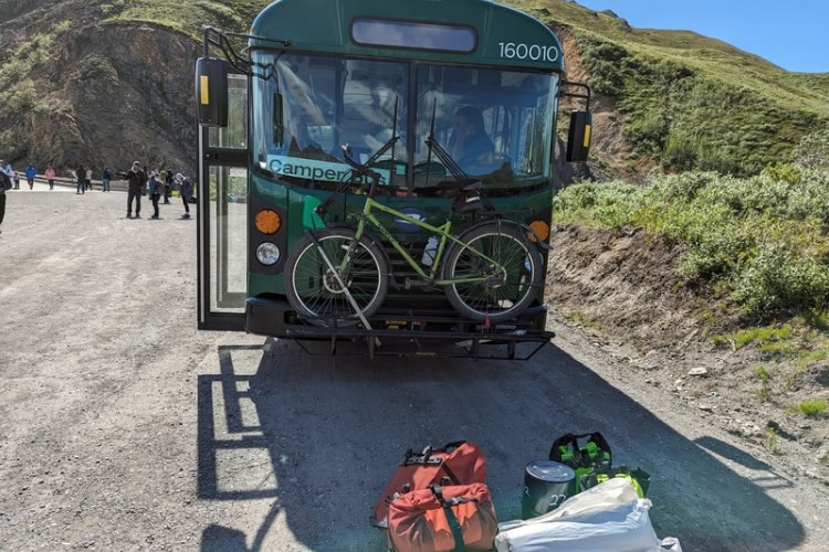
Because I had already ridden to mile 43 to check out the area, I decided this time to take the bus.
I waited somewhat nervously for the camper bus, designated for backpackers and bikers, still a little uncertain if I’d made the right decision to go alone. I was the only person on the bus with a bicycle.
At mile 43, I dropped down to the river on a long stairway built next to the road. In front of me was the braided river, beckoning me to proceed into the wild. To my right was a soaring rock cliff, beautifully colored in ochre and orange. It was exhilarating!
My strategy was to stay as close to the cliff as possible. I didn’t want to miss the road when it descended low enough for me to rejoin it. As I looked up at the massive cliff face, there was no road in sight.
River channels sometimes went right next to the cliff, forcing me to cross. Then I would cross again when the channel moved away from the cliff so that I could stay near the cliff wall.
I carefully sought out crossings where the channel had split, allowing me to cross multiple small water flows instead of one large flow.
The river was flowing fast, but I found crossings that were only mid-calf, so I was able to push my heavily loaded bike across the rocky bottom without incident.
After a few hours of hike-a-bike, I spotted the road! I was so excited, I made a beeline toward it through tall brush. It was exhausting pushing my bike uphill through brush and soft tundra.
I kept having to stop to catch my breath, thinking there must be a better route. Eventually, I found a faint path, giving me a less strenuous way to access the road.
The Road to the End
I was elated to be on the road after four hours of hike-a-bike. I looked both ways. Nothing, absolutely nothing. I had made it!
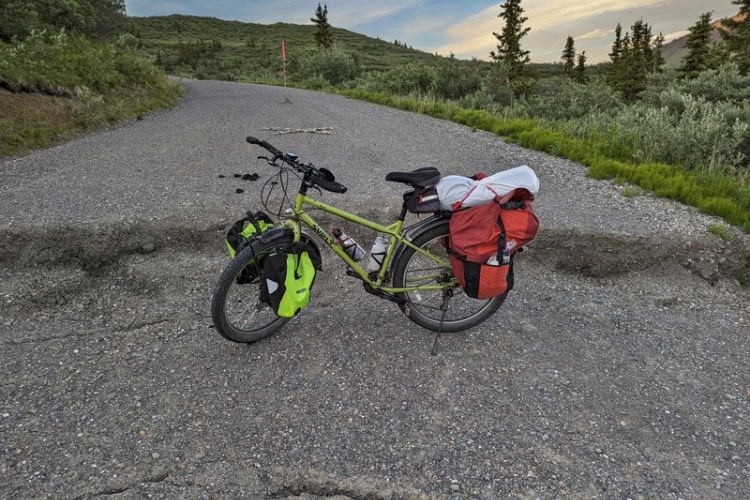
The road was gravel, unmaintained for two years, and it took a lot of attention to avoid erosion channels and washouts. As I was cruising down a hill, I saw a red flag in the middle of the road.
Wow, something must be up because there were no other markings. Sure enough, the entire roadway abruptly dropped about a foot all the way across.
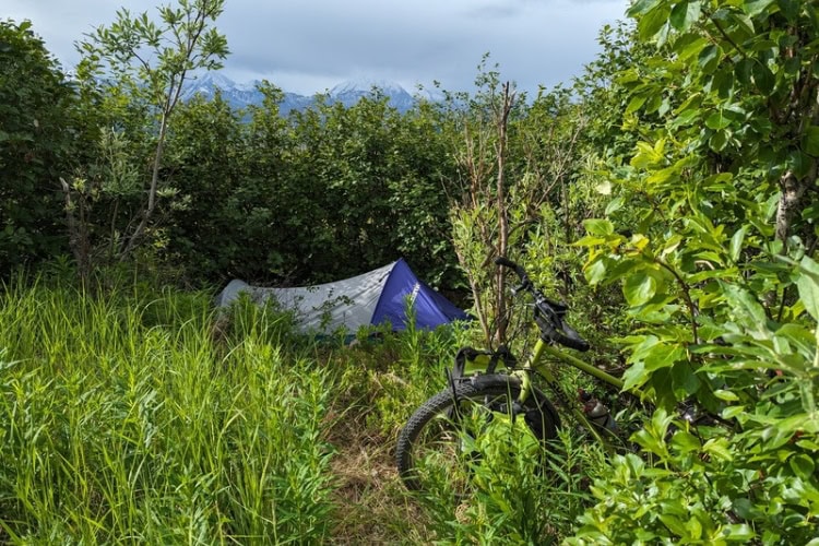
After setting my panniers and bike over the drop-off, I was soon back on my way in the glorious wilderness. I found a spot to set up my tent in some lovely pine trees at 11 PM.
A Spectacular Ride

After a good night’s sleep, I headed deeper into the park, a spectacular ride.
When I reached the closed Eielson Visitor Center perched high above the valley floor at mile 66, there were two male cyclists there, both experienced mountain bikers. They said they were traveling with a French woman, though I didn’t see her.
The closed visitor center had an outstanding view of Denali, and we watched the ever-changing clouds reveal and then hide the mountain top.
The men said they decided to camp at the visitor center and then ride back to the park entrance the next day. They heard it was buggy at lower elevation, and they didn’t want to ride down the hill just to ride back up.
I marveled at this decision. How could one come this far and not ride to the end of the road? I continued on down the road.
Reaching the End
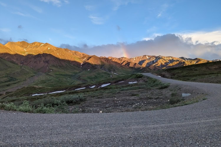
The ride to the end of the road was my favorite part of the trip. The road clung to a cliff face and a wide, flat valley opened up far below.
The impressive Muldrow Glacier came into view on the other side of the valley. Views of the snow-capped Alaska range were breathtaking, with Denali looming up ahead as the road descended into a forest.
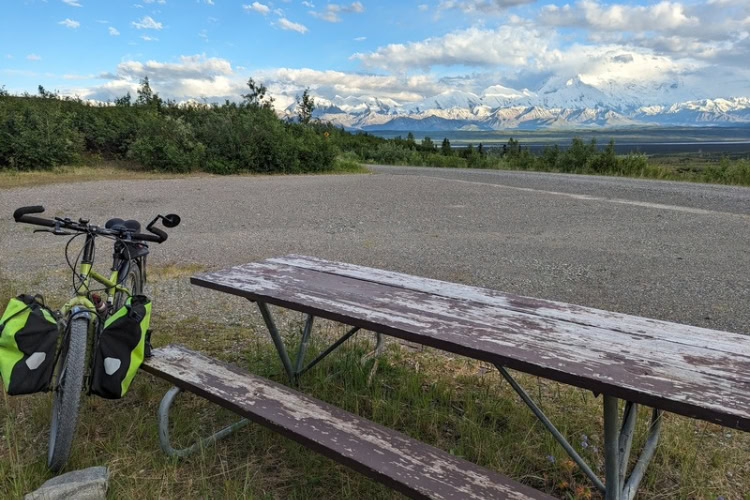
It was definitely buggy. The mosquitoes were relentless, but that’s part of the Alaska experience. I set up my tent, then rode another hour to Wonder Lake at mile 85 and cooked dinner at a picnic table with a magnificent view of Denali.
On the way back to my tent, I saw a mama duck with her cute ducklings swimming in a little pond next to the road at midnight.
I had seen many wild animals, including a grizzly bear, but it was magical to find these little creatures swimming in the midnight sun.
The Culture Shock of Kantishna
The next day I continued to Kantishna, a speck of private land surrounded by national park, at the end of the road. What a culture shock to find huge, exclusive resort complexes nestled in the trees.
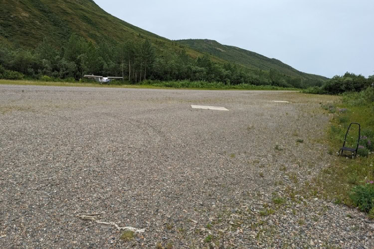
I passed the Kantishna airstrip, where well-heeled tourists arrive by small plane, though the area was eerily quiet at the time.
The Turnaround and Return
At the very end of the road at mile 92 is a loop turnaround, but no sign. Signs marking the mountain passes were missing as well. If anything was left, it was just a short post. I’m told bears use the signs as scratching posts and break them off.
I loved being in the backcountry, but it was time to head out of the park and continue my Alaska tour.
As I pedaled back up the hill toward the closed Eielson Visitor Center, I was stopped by the pickup truck from Kantishna searching for the French woman.
The truck drove on ahead to the closed visitor center where the woman had spent the night, but soon returned without having found her.
Challenges of the Return Journey
When I reached the Toklat River bridge at mile 53, the crosswind was so strong that I couldn’t ride for fear of being pushed off the low-sided bridge.
I even struggled to walk my bike without being blown over. I made it across and found a camping spot on flat river bottom next to high, orange cliffs.
The next morning, I rode until I saw a small laminated paper sign around mile 47 instructing backcountry users to exit the road to circumvent the slide.
What an easy descent it was on a wide, rocky wash. I was glad I wasn’t bushwhacking with my bike as on my way up.
My strategy on my way back around the slide was to cross the river as few times as possible. This meant I would be swinging away from the cliff, but I wasn’t concerned about missing the road because I knew where it was.
I crossed the river only twice compared to six times on the way in due to my inbound cliff-hugging strategy. Good thing, because crossing the river was more challenging on the way back due to rain upstream.
Reflecting on the Adventure
I climbed the stairway to join the road at mile 43, then rode to the park entrance while contemplating my trip. My personal takeaway is the most rewarding accomplishments are those you weren’t sure you could do.
Upon reaching the park entrance, I went straight to the wilderness center and asked about the French woman. The ranger told me that she made it out, but had a rough time.
She started her way back earlier than her travel partners because she knew she was slower. She descended the wrong wash, and her travel partners apparently passed by during that time.
When they got to the bus turnaround at mile 43, she wasn’t there so they reported her missing. A ranger contacted a resort at Kantishna and asked them to search for her. Hence my encounter with the pickup truck.
In the meantime, the French woman realized she had descended the wrong wash and climbed back up to the road. She continued on the road to the correct wash but fell in the river, and ended up with bruises and soaking wet gear.
She finally made it around the slide to catch the last bus back to the park entrance.
I was relieved that the French woman was safe. I had been thinking about her for miles.
A Proposal for Protecting the Wilderness
I am grateful to park staff who made the decision to allow bicycles to circumvent the Pretty Rocks landslide. I suggested to the rangers that the slide is a feature, not a problem.
Why not protect the wilderness in stages – private automobiles to mile 15, park buses to mile 43, bicycles to mile 92. After all, the permafrost will continue to melt, and the Park Service will spend millions of dollars to keep the full road open to vehicle traffic.
The rangers told me they’d heard that before. Maybe one day it will happen, but for now, the Park Service is spending over $100 million to build a bridge around the Pretty Rocks landslide.
Author Bio: Shirley Johnson is an avid bicycle traveler and bike advocate, living in San Francisco, California when she’s not on the road.
Inspire your next adventure with our articles below:
Want to discover more hidden gems and helpful travel tips? Join our free newsletter for the latest travel secrets and travel articles.
We are reader-supported and may earn a commission on purchases made through links in this article.