If you have a sense of adventure and own a mid-size or larger SUV, consider exploring the backcountry of Canyonlands National Park in Utah. This park sits near Moab and is adjacent to its famous sibling, Arches National Park. We spent two days on 4×4 roads and added easy hikes.
The average visitor sees the park from or close to the paved roads. That means hiking short trails off the road or enjoying gorgeous views from the many scenic overlooks.
According to Edmunds, 41% of Americans have an SUV as their primary vehicle. That means 41% of park visitors have a way not just to see the park from the overlooks, but to immerse themselves in the landscape.
A ranger described the park as twice as wide as the Grand Canyon’s gorge but half as deep. Canyonlands spans 337,598 acres across three distinct regions. It is more accessible than the Grand Canyon, with 300 miles of dirt roads in and adjacent to the park.
Know Before You Go

To get into the backcountry, you’ll need a mid-size or larger SUV, a sense of adventure, and good tires. Cars lack the ground clearance SUVs have. Backcountry roads are uneven, rutted, and dip at dry washes. AWD or 4×4 helps on certain terrain. Worn or old tires are prone to punctures and have less grip.
For this story and the average SUV driver, the 4×4 trails described here are rated no higher than 3 to 4 on a scale of 10. Any road rated higher will require off-road tires and a lifted suspension.
When you head into the trails, carry extra water and snacks in case of a breakdown. I recommend a can of compressed-air tire repair and a spare tire.
Ignore every Jeep commercial where people look like they are having fun while driving recklessly on a dirt road. That is not real life. Driving slowly keeps you and your car safe.
Before going off-road, check with a ranger on current conditions and tell them what you are driving. They can help match the trail to your vehicle. Some roads require customized 4x4s and experience.
If you do not own an SUV or do not want to use your own, several companies rent rugged two- and four-door Jeeps. Simply search “Jeep rentals Moab.”
Long Canyon Road
Long Canyon Road is a good first-time drive. It is a scenic 7.5-mile point-to-point road, meaning you enter at one point and leave at another. The route takes about an hour and serves as a shortcut between Moab and Dead Horse Point State Park. The drive takes you through canyons and alongside colorful cliffs on a narrow road.
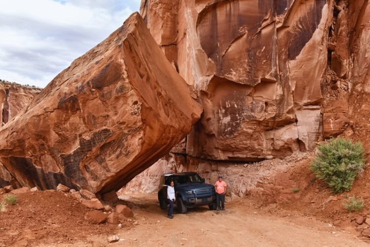
The selfie/Instagram spot is the stop under the “house-sized” Pucker Pass Fallen Boulder. This boulder fell in a landslide in 1995. The county excavated the soft debris, leaving an opening wide enough to fit your vehicle. Be patient with others taking photos.
At the end of Long Canyon Road, turn left to the Canyonlands visitor center. If you are in the park for only a day, I recommend returning to Moab via the Shafer Trail. The hike to Mesa Arch is nearby.

Driving the Shafer Trail

The Shafer Trail is my favorite in the park. It is 20 miles point to point and takes three to four hours. This popular, spectacular road descends 1,500 feet along tight switchbacks on tall sandstone cliffs.
The National Park Service calls this road “challenging.” After driving it three times over 15 years, I would say it is more “white-knuckle” for a beginner. The trail starts on a narrow road that turns into several tight switchbacks with drop-offs.
To drive this, keep both hands on the wheel and a foot on the brake to stay slow. I usually put the car in a lower gear and pay attention. At the switchbacks, your speed will drop to 2 mph. There is nothing technical or dangerous here for any SUV with good tires.
You will just have to step out of your comfort zone during the first part of the drive. Once you complete the switchbacks, about 20 minutes in, the rest of the road is easy.

I like the Shafer Trail for its incredible scenery, which takes you down to the canyon rim. It also connects to the White Rim Road (a free permit is required), where a 10-minute, 2.5-mile detour brings you to Musselman Arch. Musselman Arch (technically a natural bridge) is level with the ground and has a 300-foot drop-off.
Although the NPS prohibits walking across, we observed people doing so on our visits. Do not walk across this 187-foot-long, six-foot-wide span if you fear heights or if it is windy.

Highlights include a stop at the Gooseneck to see the Colorado River make a 180-degree turn below the cliffs. Nearby is Thelma and Louise Point, where the stars drove over the cliff into the gorge at the end of the movie.
Looking north and up is Dead Horse Point State Park. The views from the top of Dead Horse are among the best.
The last section has you drive along the gorge to your right and colorful cliffs on your left until the road veers away from the river. Near the end, you will pass the potash ponds and the balancing Elvis Rock before reaching the road back to Moab.
It is best to drive this road downhill from west to east. Never drive it when it is wet.
Visiting the Gemini Bridges

The Gemini Bridges Road is an easy, scenic point-to-point route. It is 14 miles long and takes about 90 minutes. The highlight is the pair of natural bridges called Gemini. A bridge differs from an arch as it is formed by running water.
Gemini Bridges are twins, as their name implies. Each bridge is about 100 feet long and spans 100 feet above the canyon floor. There is a parking lot that marks the location. From there, it is a three-minute walk to the side-by-side bridges.
Coming from the parking lot, the initial impression makes them look like two long, narrow rock walkways. When you walk to the opposite side, you can make them out clearly. To see them better, take the nearby dirt road to the canyon bottom, where you can walk under them.
Visitors are allowed to walk across the spans. Hold the hands of any children in this area. The view from the opposite side of the bridges overlooks the canyon below.

Another geological highlight near the end of the trail is the Gooney Bird Rock. You will see the easy-to-spot bird head at the narrow entrance to Little Canyon.
Hiking in Canyonlands

Canyonlands has hundreds of miles of hiking trails, rated from mild to wild. We hiked three easy, diverse trails ranging from 1 to 3 miles.
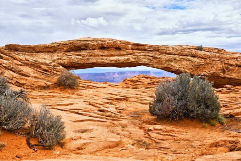
Mesa Arch is six miles from the Canyonlands visitor center. This is one of the most popular and photographed places in the park. It is an easy 0.6-mile round-trip walk with a 60-foot elevation gain.
Sunrise is best if you want to capture the rays’ glow inside the top of the arch. Sunset is another great time because the canyon 500 feet below glows.
Our visit came at a rare time with few people because it had just rained. When at Mesa Arch, rest your phones and cameras and enjoy the moment. Consider bringing a picnic breakfast or lunch.
The Upheaval Dome Trail leads to a large crater that a ranger described as a geological mystery. Walk 0.3 miles to the first overlook, or continue another 0.3 miles to the second overlook.
Upheaval Dome is a circular, tilted geologic formation spanning about 3 miles across. Geologists debate its origin. Evidence of shocked quartz suggests an ancient meteor impact. Another theory suggests a salt dome pushed up through rock layers and collapsed.
White Rim Overlook
The White Rim Overlook trail is 1.8 miles round trip, with an elevation gain of 180 feet, and takes about 1.5 hours. You get a lot of views with little effort.
This hike offers 360-degree views of the Colorado Basin. You also see the steep drop-offs and curves of the gorge and parts of the White Rim Road weaving through the canyon.
For the best lighting, visit in the late afternoon. Parking at the Gooseberry Trailhead is limited, so be patient while waiting for a spot.
To pick a hike that works for your ability, visit the trail link at https://www.nps.gov/cany/planyourvisit/hiking.htm. During your visit, see a ranger at the visitor center to check the latest conditions and recommendations.
Lodging in Moab

Accommodations in Moab range from 1 to 5 stars, with most averaging in the 3-star category. Most hotels and restaurants are on or just off US 191, the town’s main drag.
We opted to rent a condo at the Sage Creek Resort. We found our modern two-bedroom condo a better value than two hotel rooms. This place has a big pool, BBQ grill, and hot tub.
For campers and condo renters, we recommend the City Market. It is a full-size supermarket with everything you need.
Where to Eat in Moab
Blu Pig BBQ is the place for good BBQ and music. My cut of smoked prime rib was perfect. Others found the ribs and chicken very good. Service was timely and friendly. Dine in the bar area for a livelier atmosphere.
The Broken Oar Restaurant is a popular place that offers steaks, salads, pasta, and burgers.
My favorite was the Beast Burger: a half pound of ground elk, ground bison, wagyu beef, and wild boar, topped with cheddar and sautéed onions on a toasted brioche bun. They do not take reservations.
For complete activities, dining, and lodging, visit https://www.discovermoab.com/
Need a hand planning your trip? Here are the sites and services we rely on most, from booking tools to travel products we love.
Inspire your next adventure with our articles below:
Author Bio: After 30 years, Tab Hauser left the business world and reinvented himself as a journalist and professional photographer. His travels have taken him to seven continents and 100 countries or unique locations. He is an Explorers Club Friend, a member of the New York Press Association, a diver, and a U.S. Coast Guard Licensed Captain. This native New Yorker now calls Colorado home.
Want to discover more hidden gems and helpful travel tips? Join our free newsletter for the latest travel secrets and travel articles.
We are reader-supported and may earn a commission on purchases made through links in this article.

For those that are planning an exciting adventure that includes hikes and/or off-roading in the Canyonlands, this story is your starting point. Thanks for sharing this information and great pictures with us.