
Go World Travel is reader-supported and may earn a commission from purchases made through links in this piece.
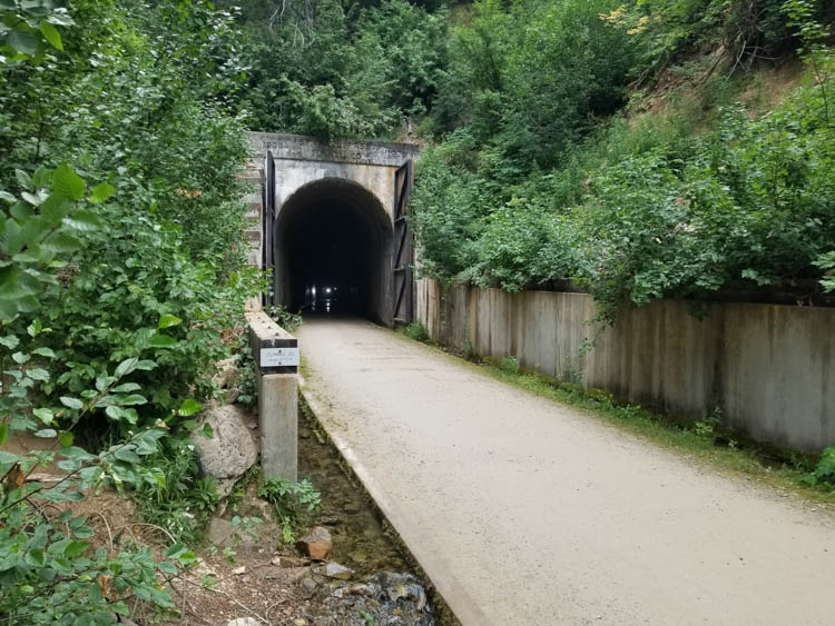
The light at the end of the tunnel won’t come to me; I must go to it. But before getting there, I must ride a bike through a dark and dank underground tunnel with tall arched cement walls. I felt crisp, chilly air on my face punctuated with the sounds of dripping water. Was this what it feels like to be in a mine shaft?
Fortunately, the light on my bicycle’s handlebar cut through the dinginess. What could have been scary was instead quite thrilling. And although the dot of light signaling the tunnel’s end grew bigger, my morning bike ride was just beginning.
About the Hiawatha Bike Trail
The Route of the Hiawatha Trail near Lookout Pass, Idaho, is considered a Hall of Fame Trail of the Rails-to-Trails Conservancy. This organization converts America’s abandoned train tracks into biking and hiking trails. What used to be the Chicago, Milwaukee and St. Paul Railway’s Pacific Extension is now a 15-mile-long scenic bike route.
Before you balk at the prospect of such a long trail, take note – it’s almost all downhill. No huffing and puffing is necessary because you can coast the whole way.
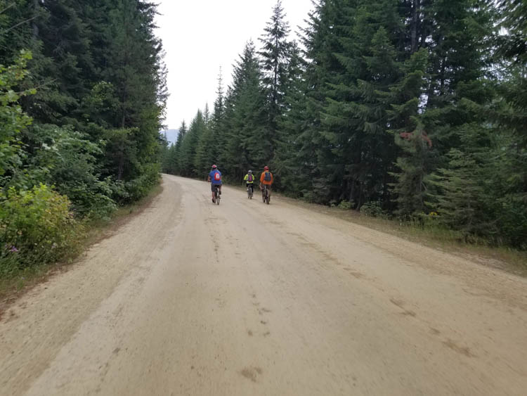
Even better, the trail follows the crest of the Bitterroot Mountains through beautiful subalpine forests. Riders travel through 10 old railroad tunnels and across seven train trestle spans that float above treetops.
Best Tips & Tools to Plan Your Trip
First opened in 1998, the trail has expanded over the years and now connects to other trails in the region. However, Hiawatha’s gentle two percent grade slope makes this trail accessible to riders of all ages and abilities.
It is perfect for families with young children. Or older adults who enjoy the outdoors but aren’t experienced enough to tackle single tracks. Not only is the route easy, everything you need – from bikes to helmets to a shuttle ride back to the top – is available for visitors to rent.
What to Expect
My trail day began with low grey clouds. But the August air was warm when I picked up my ride at the trailhead, a teal-colored Diamondback with some well-earned scratches on its sturdy frame.
As I adjusted the seat height, I overheard a guy call the trail “cheating” since there’s hardly any pedaling to do. That’s because the trail began at 4,147 feet above sea level on the Montana side of Idaho’s panhandle before heading downhill.
However, you do have to pedal through the first and most impressive part of the trail, the 1.66-mile St. Paul Pass/Taft Tunnel going through a mountain. Between the parking lot and the trailhead was a tent where riders check in and receive their rental bike, helmet, and light, if needed (lights are required). People can bring their own equipment but still must purchase a trail pass.
Light At the End of the Tunnel
The St. Paul Pass Tunnel marked the beginning of the trail. Once inside, there was a tiny hazard to watch out for: small drainage gutters on both sides. According to rental staff, the gutters weren’t deep. However, they were filled with cold, flowing water.
In the dark of the tunnel, especially if you’re chatting with fellow riders, accidentally slipping a tire into one was easy to do. To avoid this inconvenience, pay attention and stay near the middle. About halfway through the tunnel was a sign marking the Idaho/Montana state line.
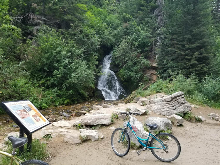
While the light at the tunnel’s exit was a welcome sight, more spectacular views awaited on the other side. The first is a picturesque waterfall. There’s also a picnic area here and vault toilets nearby.
There are four trail restrooms. One at the top and one at the bottom of the trail. Plus, one at the tunnel exit and another at the trail’s horseshoe curve about halfway down.
From here the emerald forest of the Bitterroot Mountains rippled beneath the misty cloud cover. The trail itself was wide and flat, a mix of pea gravel and packed earth. As I coasted along enjoying the view, I heard a bicycle bell. Glancing to my left, a woman and two small boys approached on their bikes.
“Excuse me,” she said. “No problem,” I responded. One of the boys waved as he passed.
History of the St Paul Railroad
At the turn of the 20th century, the Chicago, Milwaukee, and St. Paul Railroad already went deep into the upper Midwest. Looking to capitalize on the Pacific Coast trade, the owners commissioned an extension all the way to Seattle over the Montana and Idaho mountains.
It took surveyors years of trekking just to find a route through the area. Blasting and digging through the mountains, erecting giant trestles over the valleys, and hauling tracks and supplies to the builders was difficult and dangerous work, but after two years of construction, the intercontinental railroad from Chicago to Seattle opened on July 4, 1909.
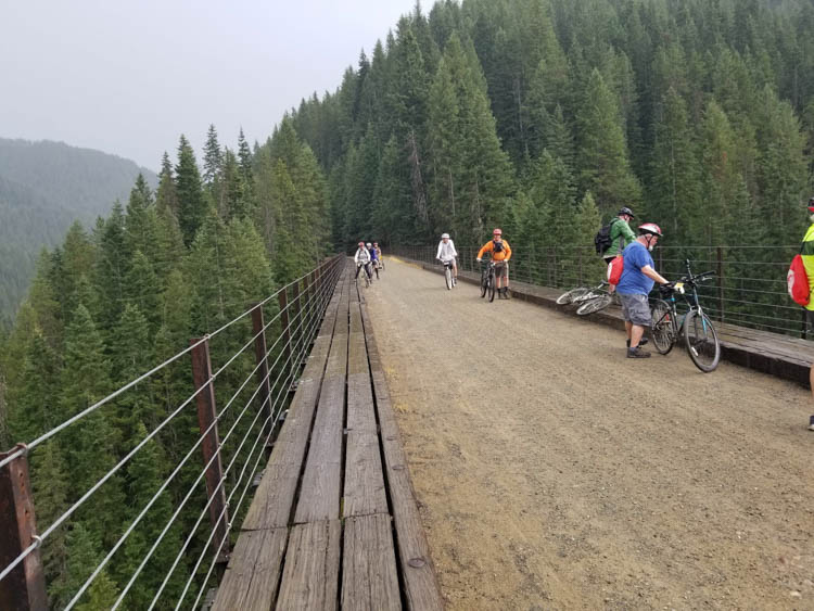
I passed through four much shorter tunnels before coming to the first trestle span over Small Creek. It’s 515 feet long and 120 feet high and was above the trail’s horseshoe turn so I could see the lower trestles on the other side below.

The trail’s longest span ran over Kelly Creek at 850 feet long and 230 feet high. Although I felt completely safe biking the span, I had a hard time imagining a heavy locomotive loaded with timber or coal ambling over the wood and steel cross-braced structures. The latticed trestles resembled an intricate erector set.
The Route of the Hiawatha Trail gets its name from the name of the trains used by the railroad company. They were named for the mythical Native American figure in Henry Wadsworth Longfellow’s epic poem The Song of Hiawatha because, like the legend, they were the fastest and strongest in the fleet.
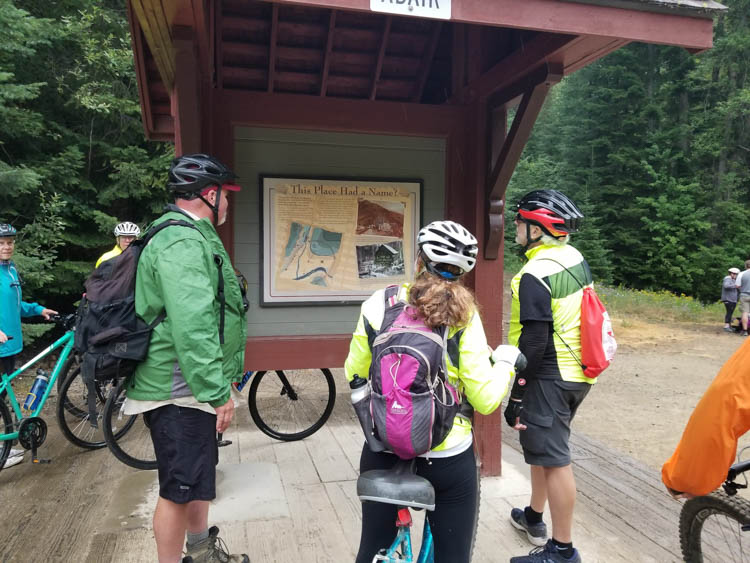
I found this information in one of the 47 interpretive signs along the trail explaining the railroad and the area’s colorful history.
Reaching the Lower Trail
Two more short tunnels got me around the curve over Loop Creek and closer to the bottom third of the trail. I now ride over the lower trestles that I saw from above. The last one over Clear Creek is 760 feet long and I stop to photograph the view.
Along the edge of the trestle were wooden planks that have just enough of a gap between them to see through to the creek 220 feet below. Depending on your opinion of heights, it was either super cool or kind of scary.
After passing through two more tunnels, the trail flattens out somewhat and I needed to peddle to keep my momentum, but it’s a leisurely pace. There’s no hurry. Finally, the clouds dissipated and the sun poked through with spots of blue sky between the mountains.
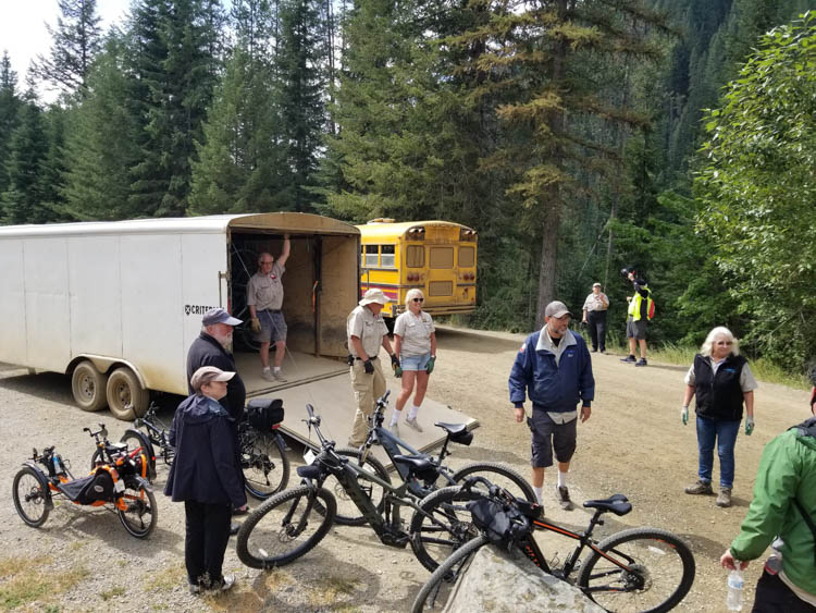
One last tunnel and I arrived at the bottom trailhead, 967 feet below where I started. Like the upper trailhead, there are staffed tents selling food and drinks next to a parking lot.
Shuttle Bus Back to the Top
Here school buses will take riders and bikes back up. Shuttle rides cost extra and don’t run on a schedule, only leaving when full. I’m told on busy weekends, there can be a bit of a wait. Staff quickly loaded my bike on a trailer with other bikes and I boarded an almost full bus.
It’s slow going up the gravel road switchbacks, but our driver entertained us with her stories about area wildlife and pointing out places of interest.
However, the bus didn’t take us all the way to the top. It stopped at the west entrance of the St. Paul Pass/Taft Tunnel where we must ride through it again to get back to the car.
As the temperature rose with the late morning sun, the tunnel’s constant 47 degrees made this last mile and a half of peddling cool and refreshing. When I emerged back at the parking lot, it was time for lunch and I hadn’t even broken a sweat.
Hiawatha Trail Info
https://www.ridethehiawatha.com/
The Route of the Hiawatha Trail is open from mid-May through mid-September. Online reservations for summer begin on January 1.
Whether you rent or bring your own bike, passes must be purchased to access the trail. It is recommended that passes and rentals be purchased in advance online, especially for busier days like holidays and weekends.
Passes can be purchased at the trailhead with cash only. Rental equipment can be picked up at the Lookout Pass Ski Area or for a fee you can have it delivered to the trailhead.
All riders MUST have a headlight, either your own or you can rent one. Snacks, cold sandwiches, water, and soft drinks are available for purchase at both trailheads. Helmets are recommended for adults and required for those 18 and younger. Children 14 and under must be accompanied by an adult.
For those wanting a more challenging ride, you can ride back up the trail instead of paying for the shuttle or start from the bottom and enjoy the descent on the return.
See the website for maps and directions.
Inspire your next adventure with our articles below:
Author Bio: Carrie Dow is a freelance writer based in Charlotte, NC, whose work has appeared in regional and national magazines. She is also the founder of What’s Pawsitive, a website that profiles animal-based travel, animal rescue organizations, and animal welfare advocates around the world.