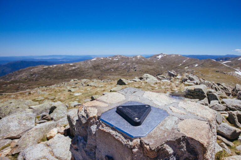
The highest point of Australia, Mt Kosciuszko, stands at 2228m and is undoubtedly the easiest of the highest summits of any continent. The endeavour, though, still includes a very long 13.5 km walk for the return hike.
Add in a few more kilometres if you do not prefer the cable car that takes you to the start of the walk. Though not very steep, the scenic walk in the National Park is perhaps one of the best day walks you should attempt in the country.
The Easiest of the Highest Summits
Whatever, ignoring the ardour, a summit is a summit – a badge to display proudly that you have ascended to one of the seven summits – an admirable club of conquering the highest peaks in each of the seven continents.
Some avid enthusiasts claim that pronouncing the peak is tougher than hiking it – so they happily substitute the Kosciuszko in Australia with the much higher Carstensz pyramid (or Puncak Jaya) in Indonesia, replacing continents with continental shelves.
Nonetheless, it is a brilliant walk in an expansive National Park and is a worthy experience to collect.
My fascination with Kosciuszko started last Winter when I had been to Thredbo, the nearest town, to see the winter snows of Australia. This part of the Great Dividing Range – the Snowy Mountains – receives ample snow; naturally, it is not possible to tread all the way to the peak.
But being the experienced collector I am, I couldn’t resist the temptation of ticking off this nice little box (remember the tag of the Seven Summits, mate!) So next summer, I was up with a motley group of friends to walk to the top and scream a-la-Hillar,y ‘Because it is there!’
We were blessed with a sunny day in an apparently cloudy, rainy week, as the summit walk is quite windy and cold, and a warm sun suddenly seems so cheery. There is a cable car to the base and takes about 10 minutes. It offers wonderful views of blue-hued mountains far away, not to mention the quaint little alpine town of Thredbo.
You can hike all the way from Thredbo as well, but I would recommend taking the cable car to spend most time on the top – if you are still eager after 14 km of walking, just walk down and enjoy the track.
You will also find the Eagle’s Nest Café at this starting point, which is reputed to be the highest café in the entire continent.
The Walk Is Actually Quite Comfortable
The walk is actually quite comfortable and goes along steel frames laid on the track just until the end. While it makes the walk definitely easier, it does remove the natural feel, but then stems the erosion of the apparently sensitive ecosystem at the top.
It also hints at the steps taken by the proactive tourism department here to popularize and commercialize the hike, and the result is quite apparent. I ended up walking with hundreds of ramblers, including toddlers and kids. At times, it actually felt like a merry pilgrimage along a long, sinuous track.
The landscape is beautiful, albeit in a sparse way. There are no trees to be found throughout the walk at this height, just snaking shrubs and alpine flowers sporting romantic names such as the billy button, the mountain celery, alpine marsh marigold, mint bush, anemone buttercup and the silver snow.
Then there are the occasional streams snaking around, creating swampy bogs to beautiful blue rivulets along the way. If you are lucky, you might even spot a pygmy possum or a bright-hued flame robin enjoying the altitude on a quiet day.
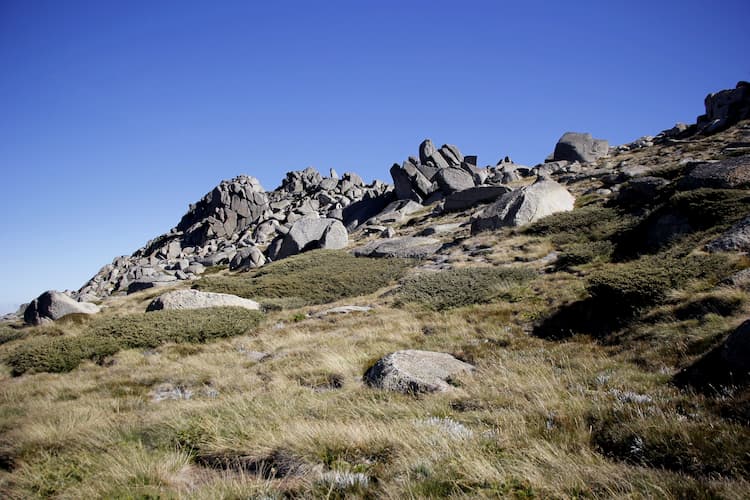
And then there are the boulders – piled, striated, cracked, and lying like age-old sentients watching time pass by.
Long ago, during the glacial ages, these were dragged on for miles by the moving glaciers – today, they lie pell-mell all over the hills and create a beautiful, at times surreal lunar landscape of empty plains and piling rocks, conquered a bit more every winter, when melting snow seeps into the cracks, freezes inside, expands and cracks and splinters these to smaller pieces.
To be honest, such an expanse moved me, and for a brief moment, I went astray from the normal path to climb a rocky hill afar, seeking my solitude away from the madding crowds.
It felt ethereal to imagine this same place a hundred thousand years ago – left alone to itself, all so quiet except for the gushing streams and whistling winds.
And yet it opened up to the ancient aboriginals who claimed that this was where their spirits lived and danced in the bare and raw beauty of this endlessness.
A Home to Aboriginal Peoples
For hundreds of years, these tribes have also been congregating here to feast on the Bogong moths in summer and to conduct their spiritual rites. It took some time to break my reverie of ancient aborigines, cave-dwelling here and dancing with their primeval spirits under the starlit sky.
I had to walk along and, of course, place a tick on my coveted seven-summit check box.
A Beautiful Multi-Colored Lake
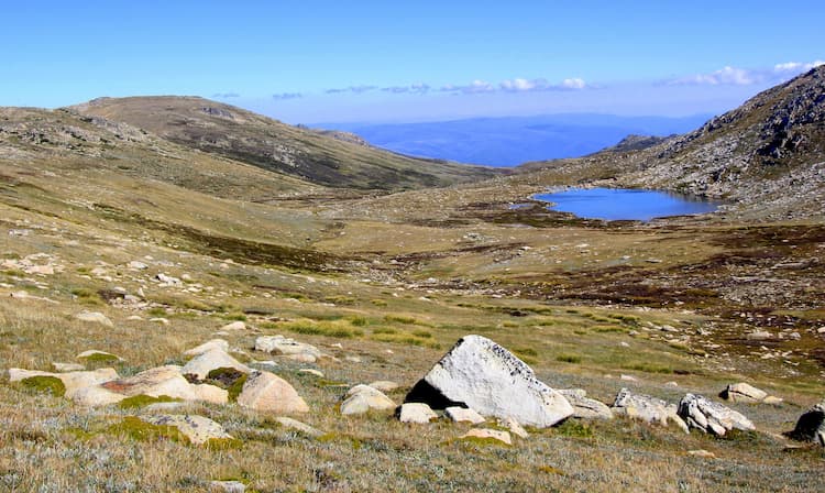
The other moment of redemption that I had here was on seeing a large lake fascinatingly called Cootapatamba. Like other alpine lakes here, it was once a cirque – a hollow formed in the hills by glacial erosion and later collecting water to form a beautiful lake in the mountains (called a tarn).
It was nothing significant – just a small body of water, but one that magically changed colours from moss green to muddy blue and then sapphire blue as you walked on and changed the angle of viewing it.
I think what fascinated me once again was its antiquated past and the immense changes in the landscape it must have seen once.
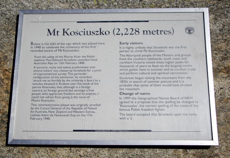
For the record keepers, yes, it is the highest-altitude lake in Oz. The name is, as you would have guessed, Aboriginal in origin. (Talking of names, the peak itself was named by a Polish explorer, Paul Strzelecki, who decided to name it rather arduously after the Polish national hero Kościuszko).
The way to the end is scenic all along – just before the summit, another dirt track joins it from Charlotte’s Pass and would be an excellent choice for those wanting a natural feel under their sole instead of the steel grilles.
It Deserves a Walk
I finally reached the top after 3 hours of slow, steady walking after infinite clicks on my camera in a desperate attempt to hold on to all the raw beauty that was afloat. Reaching the top was my moment of satisfaction. So what if it is way easier than the Aconcagua?
It is beautiful and deserves a walk, just for the serenity, for the ancient images it evokes in the mind, for the sonata of the wind and the waters under a smiling sun. Yes, it deserves a walk just because it is there!
Fact File:
- The nearest town is Thredbo, 6-7 hours from Sydney
- Alternatively, stay at Jindabyne (and enjoy its famed lake at dusk after the walk), which is a 30-minute drive away
- Once done with the walk, keep a day for Charlotte’s Pass, another small spot about 30 minutes from Jindabyne. It offers multiple walks in these hills: long ones include hikes to the Blue Lake (10 km return) and an alternate route to the Kosciuszko (20 km return). There are numerous short walks too – we took one to Mount Stilwell and were rewarded with a beautiful, moderate walk, but with far fewer people, allowing us to enjoy the hike on our own.
Need a hand planning your trip? Here are the sites and services we rely on most, from booking tools to travel products we love.
Tip: Climbing to the summit is a truly memorable challenge, and custom enamel pins are a wonderful souvenir to commemorate it.
Inspire your next adventure with our articles below:
Want to discover more hidden gems and helpful travel tips? Join our free newsletter for the latest travel secrets and travel articles.
We are reader-supported and may earn a commission on purchases made through links in this article.