The southern-most state of Mexico bordering Guatemala, whose name, Chiapas, means ‘place where chia grows,’ currently is one of the safest places in Mexico with few CoVid-19 cases. It also boasts the country’s largest indigenous population, seven geological regions from sea level to 13,390 ft., and the greatest diversity of animals and birds in all of the Americas. It waits to stun the senses.
Thirty years after my first encounter with its enchantment, I revisited Chiapas. I found the culture struggling in a time warp, descendants of the Maya hanging onto their traditions by a thread, the environment frayed by the development of infrastructure, and the beauty of nature’s wonders feeling less remote.
I had to look closely, deep into the soul of the area and its people to find that the mysteries of Chiapas still remained, fragile but intact. Winding through this land of contrasts, we circled the state, beginning and ending on the Grijalva River. Starting out in the capital, Tuxtla Gutierrez, I thought about Willie Nelson’s tune, Far Away Places with Strange Sounding Names.
Sumidero Canyon
Located only 6.2 miles from Tuxtla Gutierrez airport, the ancient town of Chiapa de Corzo provided the jumping off point for our journey through the Sumidero Canyon. Thought to have formed 35 million years ago parallel to that of the US Grand Canyon, Sumidero was declared a National Park in 1980 and ranks as the main tourist attraction in Chiapas.
As we pulled into the boat launch area, the 100 meter wide Rio Grijalva raged from torrential, rainy season downpours. The river source springs in the southeastern Lacandon Jungle, then zigzags through the state, flowing into the Gulf of Mexico above Villahermosa.
In mid-October, the slow tourist time, hundreds of high-season, 16 passenger motor boats stood idle. Inside the shanty ticket booth, a drowsy, young Mexican lad sprang to his feet, roused by the excitement of two visitors. He gingerly fastened neon park pass bracelets around our wrists.
Our dinghy boat driver introduced himself as El Capitan′ Juan Miguel for our three hour excursion. He handed us the latest safety rage in Mexico, life jackets. As we slipped into the river’s current, the National Park rangers, who stood on a stone jetty high above, scanned our boat through binoculars. We jiggled our wrists and raised our arms to show off our bright green ornaments. No one enters the canyon without this proof of purchase.
Sheer limestone canyon walls soared upwards 3,280 feet, creating continuous natural vistas. The park land, lying on a geological fault, provides habitat for spider monkeys and pumas, while the river acts as a breeding ground for crocodiles. Spying a hefty croc sunning on the shore, we pulled our life vests tighter as he slid into the water, eyeing camera toting meals.
Ominous dark clouds formed overhead and within minutes the faithful afternoon rains pelted us. Juan Miguel, undaunted, maneuvered his craft through the canyon. Out came the first of many paradoxes. A huge blue, plastic tarp saved our cameras and our fragile, eco-tourist skins from the stinging welts of relentless raindrops.
Plastic bottles and bags, strewn everywhere in Mexico, rank as the worst inorganic garbage problem. Yet, here we were, huddled under impenetrable coverlets, praising their water repellant properties.
Soon the boat slowed to a drift. We entered a bottleneck in the canyon called the Tube of the Drain. Nothing prepared us, as we peeked from our plastic protection. From shore to shore, tree limbs, roof tiles, plastic Squirt and Coca Cola bottles, oil drums, everything not nailed down during rainy season deluges, clogged the entire ravine.
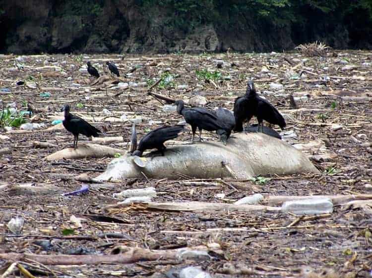
The river vanished. The air turned rancid, as dead cattle, horns wafting above the stench, pigs, goats and donkey’s bloated bellies rounded above the hidden water. Peyotes (turkey vultures) stood upon this rotting feast, defiantly peering at the intruders interrupting their dinner. They walked across the floating garbage dump.
We all tensed, praying that the boat’s propeller would guide us through the contaminated muck. Interrupting the beauty, we faced the ugly realities of the conflict between the life sustaining properties of water and the natural destructions caused by it.
Every year, the torrid rains grab over 5,000 tons of organic and inorganic waste from 14 surrounding municipalities, plunging the spoils over the precipitous cliffs into the Rio Grijalva. It flows downstream until the narrowing convergence of three cliffs brings it to a dreadful halt.
Boat navigation becomes difficult, transit of crocodiles slows and tourism suffers. The state of Chiapas spends over 2 million dollars a year, ridding the river of this contamination. I cringed at the thought of having the job of cleaning up this or any natural disaster.
Safely through the solid waste, beauty magically retuned. An amazing sight on the right side of the canyon walls offered a welcomed distraction. Known as the Christmas Tree ( arbol de Navidad), a waterfall spilling from a hole at the top of the limestone cliff, splashed down on a series of moss layered rocks, lichens and ferns that transformed the stone surface into a towering wispy fir tree.
Nothing exists like it anywhere in the world, according to El Capitan. I forgot about the ‘ugly’ and soaked up the splendor instead. A silent mist sprinkled us while on the opposite canyon wall, a plunging cascade thundered.
Our canyon journey ended at the breast of the Chicoasen Dam. Chiapas boasts over 100 hydroelectric plants, and provides enough electricity to sell current to Honduras, Belize, Guatemala and Southern California. Over 400,000 visitors embark on the Sumidero Canyon yearly. It provides a unique introduction into the contrasts one finds in the State of Chiapas, Mexico.
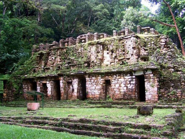
San Cristobal de las Casas in Chiapas
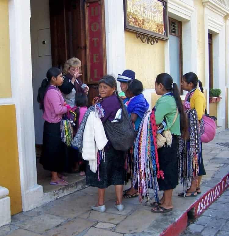
We headed toward heaven, passing again through quaint Chiapa del Corzo, once Guatemalan territory in 1524, still looking like a page from Antigua´s play book. Embroidered, Maya huipiles and bright, woven belts cinching black skirts appeared on the streets.
Our appetites for indigenous cultures wetted, we wanted to rush toward the jewel of Chiapas, San Cristobal de las Casas, but the van lumbered up the vertical ascent. There would be no rushing.
As the road switched-back, rain poured from dark clouds; then clear skies re-emerged. This intermittent dousing continued as we climbed to an elevation of 6890 feet. At the edge of the city, the cobblestone streets and 16th century architectural style mirrored other Mexican cities established during the Spanish Conquest. Young backpackers created an unusual bustle among the antique buildings and the immaculate streets as they hurried along the uneven sidewalks.
Local women, whose long black pigtails flailed and curly black sheep-skin skirts rustled, followed the herd. They wagged their hand-made dolls and beaded necklaces to entice a sale. The image of a cell phone braced against the ear of one of the hawkers remains frozen in my memory.
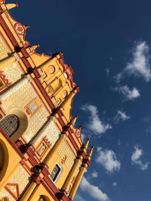
I have traveled the Maya World for 30 years and never anticipated such a melting of old and new. The Maya have maintained their indigenous traditions, but have learned to use modern technology to propel their business of trinket and textile sales. On Avenida 16 de Septiembre, fronting the baroque style Cathedral of Peace, a pedestrian-only microcosm of San Cristobal unfolded. Posh amber jewelry stores lined the street, producing the same quality and clarity of this resin as Dominican Republic amber.
I couldn’t help myself, haggled for a pendant encasing a huge chunk of rare deep red amber and left the store almost giddy. Bargaining-for anything- is considered the only polite way to conduct business.
Paying full price right off the bat takes the fun out of the exchange; when the buyer starts low and eventually agrees to the seller’s best price delight comes for both. The interaction felt as good as the purchase.
Chic, Italian, Argentine and French restaurants offer cosmopolitan cuisine, but interspersed among this sophistication, cozy Mexican establishments and Maya handicraft stalls beckon the traveler to experience the contrasts. You can sup on a full course Mexican meal for the peso equivalent of $5, and later drift next door for a mocha latte and some jazz music at a trendy coffee shop.
I pulled my rebozo tight, chilled by the brisk, evening air. The goose down quilt waiting on the hotel’s bed called my name. With elevation comes the bite. Workers setting up for a Saturday night Mexican music extravaganza placed cables, microphones and lighting in the plaza fronting the ancient church People gathered to hear the Mexican rock band while 40 ft. high floats rolled by.
A full moon looked down, as toe tapping, Maya youth stood on the sidelines, contemplating participation. Watching indigenous teenagers being tempted by the present but being pulled back by the past captured my attention. I barely heard the music.
Since the founding by Spanish conquistador Diego de Mazariegos in 1528, this city with a current population of 190, 000, has had seven name changes. Officially, it reverted to San Cristobal de las Casas in 1943, in honor of the 1st Catholic Bishop to the Chiapas, Bartolome de las Casas, who defended the rights of the native people. The irony-despite all the name changes, the natives continue to call it Jovel– the traditional, indigenous one.
San Juan de Chamula
We headed to 7200 ft. to the place billed as the Chiapas’ most authentic Maya village. 50,000 Tzotzil Maya inhabit San Juan de Chamula, which enjoys the unique position of being autonomous. The Mexican government allows this town to function independently, as Mexican federales and national military units have no authority here.
Rodrigo, a well-heeled Chiapas guide, provided the low-down on this closed society and facilitated our movement throughout the community. Tourists who show up here without a guide would be hard pressed to know all the “rules.”
With an average of 2000 daily visitors traipsing around, village elders protect their people from gawkers, with a “no photos” law and they expect local escorts to enforce it. Rodrigo paid the “gatekeeper” stationed at the town’s entrance, the fee which entitled him to park along the street. Gathering children pawed on the van door, waving beaded trinkets and jewelry. Karina, our guide’s favorite hawker, paced impatiently.
We jumped from the van and felt instant disappointment, as we waded through the persistent young entrepreneurs. It could be any Mexican municipality and we have seen plenty. Stalls with goods from all over Mexico lined the streets.
“What craft is made here in Chamula?” I asked, begging to add something authentic to this “unauthentic” experience.
“Oh, these people are businessmen, savvy commercialists. They sell everything but make few products themselves,” responded Rodrigo. I thought of the Amish back in Lancaster, PA; shrewd, economic masters who are pitied because they live without electricity, while their mattresses bulge with tobacco crop profits.
Our disillusionment faded as we turned onto the central plaza market where we spied the heartbeat of the people. The whitewashed Church of San Juan Bautista waited as the prize. After conferring with a high ranking town watchdog, Rodrigo announced that we could take a few photos of the market, but only under his close supervision.
Our guide purchased “viewing tickets” for a visual entrance into their culture, the images inside the church. The photo policeman blocked the wooden church door. Dressed in traditional garb of white pants, black, sheepskin tunic and a tattered white straw hat, the enforcer wagged his finger at visible cameras. My husband, his zoom lenses slung around his neck, tucked the camera body inside his shirt.
Rodrigo whispered that we had stumbled into Chamula on an important religious, festival day. Inside, the church hollow, devoid of any pews, thick sweet scent of Copal incense clogged our sinuses.
Long, soft pine boughs covered the bare stone floor. The forest aroma wafted with each step, and needles rustled quietly under the parishioners’ movements. Families knelt on nature’s carpet, lighting hundreds of candles and positioning them on the floor under droplets of melted wax.
The candle’s color signified the intent of family prayers: green-good land; white-food, orange-understanding and peace and black-protection from evil. Each grouping seemed unaffected by commotion only inches away. Three cuaderaños, (village healers), decked with white head cloths and black wool tunics, chanted and drank fermented Bosch in a spiritual, healing ceremony.
They wandered among the families to inquire if any member needed their services. Musicians, reclining in wooden boxes resembling caskets, played eerie tunes on accordions, drums and flutes.
The band reaped its reward during a break. Children rushed to offer them a high powered beverage with Coca-Cola as a chaser. Coca-Cola signs reigned supreme as nearly every group kept multiple bottles close to refresh them during their prayers. This coveted beverage is involved in every religious ritual. I wondered if Coke’s ubiquitous presence suggested the company’s sponsorship to maintain the church.
Strange glass cases, housing bizarre, carved, wooden representations of Catholic Saints, lined the walls, as bits of Catholicism are interwoven through their own religious rituals. Oddly, Catholic priests are not allowed inside this church as the center of the people’s devotion is John the Baptist, rather than Jesus Christ.
We tried to maneuver our way through the pine maze without disruption. Inspired by their devoutness and humbled by their tenacity for tradition, my initial sardonic impression of Chamula drifted away. Now Chamula felt authentic.
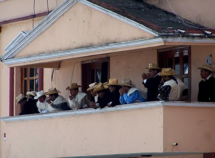
Back on the square, our attention was drawn to the village elders, who lined a second floor balcony. They surveyed the crowd, looking for any outsider who ignored their strict rules. Rodrigo advised that the penalties can be severe.
Protected Nature Sanctuaries in Chiapas
Back in San Cristobal, but bedraggled by bartering for indigenous crafts, we headed south for a day of eco-wandering. The list of Protected Nature Sanctuaries in Chiapas included three eye-popping sites: Las Grutas de Rancho Nuevo, El Cascade de Chiflon and Los Lagos de Montebello.
Ten kilometers south, the Rancho Nuevo Reserve, a forest of soft pines, begged us to walk on its carpet of silk-like needles, to glimpse the area’s abundant wildlife of foxes, weasels and armadillos. BBQ grills and picnic tables invited us to stay awhile to soak up the quiet, before exploring the reserve’s focus, an underground cave.
The grotto’s chamber of stalagmites and stalactites guided us inside the cool mountain. With the sound of an underground river rushing beneath our feet, a lighted walkway gave us a capsulated peek into the limestone caverns created millions of years ago. Our packed itinerary rushed us along, leaving behind the desire to linger.
Winding through the Chiapas countryside, we encountered a military checkpoint at the largest border town with Guatemala, Comitan, a free-trade zone city. Guatemalans, permitted into Mexico to this point without a visa, seek daily work here. After a cursive glance, the guards waved us on, certain that we were not Guatemalans who had drifted beyond the legal boundary.
Layers of clothes peeled off, as we drove on a continuous downward slope to a lower elevation. With increased temperatures and humidity, the flora gradually turned from pine and fir to palm and sugar cane.
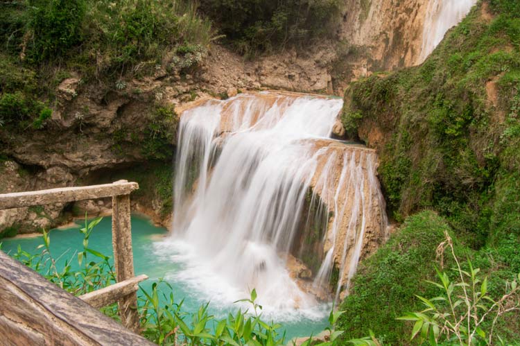
Thirty minutes from Comitan, we spotted water springing from the distant mountainside. El Cascade de Chiflon pounded with fierce force, as we entered the Eco Reserve.
Located in Mexico’s newest Eco Park, the cascade marvels onlookers year round. Our end of the rainy season arrival provided views of the water’s fullest, most forceful drop of 120 meters. A path edging the water and steep wooden steps led us toward the summit. The area revealed campsites, calm pond areas for swimming and rentable cabañas located mid-point.
Without changing facilities, bathers discarded modesty and slipped into or out of swimming suits behind a tree or overhanging branch. We climbed to the top and relished the spray of cooling waters spewing from the waterfall’s crest. Oh for more time, everywhere we went.
Pressing toward the Mexican-Guatemalan border, the Lagos de Montebello National Park waited as this day’s final feast for our eyes. Numbering over fifty lagoons, the Lakes of Montebello are scattered throughout, surrounded by virgin forests.
Although locals offered horses for hire to explore the park, we found eight lakes accessible by car via dirt and gravel roads. Rigged up food stalls by local women at several parking/viewing areas provided us with a yummy quesadilla stop.
A “Lakes of Colors” mantra describes the lure of these waters. Laguna Agua Tinta throws off hues of intense turquoise, while Lago Bosque Azul radiates deep blues. Laguna Tzescoa, the largest and most southern lake, lies partially in Mexico, while the tip rests in Guatemala.
Although rules strictly forbid fishing, swimming is permitted but due to remoteness, lack of medical facilities and lake depths of several hundred feet, the buddy system is imperative for all park activities.
Insect repellant and hiking boots served us well, as we meandered through the sweet air and serene environment. On several of the larger lakes, rafts fashioned from tree trunks tied together, small oared skiffs, campsites and rudimentary cabins are available to rent.
Zapatista Checkpoint on the Way to Palenque
We snaked our way downward, bouncing over 190 topes (Latin American speed bumps) during the six hour trip to Palenque, in the Chiapas lowlands.
Our route took us through steamy Ocosingo and other Zapatista controlled municipalities as we headed toward dense jungle. Known as EZLN (Zapatista Army of National Liberation), this social/ political movement headed by sub-commandante Marcos, took over control of five towns in Chiapas, Chamula among them, on New Year’s Day, 1994.
Although not officially recognized by the Mexican Government, this group enjoys an unspoken truce, without Mexican military action against them since 1995. Organized for the principal purpose of land control and to empower the inhabitants, the movement favors the indigenous population, who had few rights prior to the takeover.
Along the way, we encountered several roadblocks, crafted by fraying ropes stretched across the macadam and manned by local Zapatistas, rifles in hand. Although these limp pieces of hemp would not stop any vehicle from gate crashing, no one would think of it. The guns maintain the order.
We dutifully paid the requested toll for the privilege of driving through Zapatista controlled land. At one spot, only a few kilometers separated one roadblock from the next. The Mexican government does not sanction this toll road extortion, but neither does it challenge the practice.
EZLN t-shirts, sporting pictures of leader Marcos, with his black stocking mask hiding his identity, remain top sellers at road side stands hawking area souvenirs. We snapped one up for our grandson, who would be intrigued by the top dog’s disguise.
The mystique of Marcos and the Zapatista movement gives this entire area an unspoken aura of the unknown and the ungoverned. Yet, it seems to have worked for many years. The indigenous people feel that they have a voice, but how loudly they are heard is unclear.
In route to Palenque, we revisited two natural wonders, the cascades of Aqua Azul and Misol Ha. Thirty years earlier, we made our first discovery of these refreshing, water recreation spots on our initial exploration of Palenque. Stunned by recent commercialized development at each site, we walked by rows of vendors and restaurants.
Up stoned and railed steps toward the top of the falls at Aqua Azul and down to the base of the cascade at Misol Ha, where we crept beneath the pounding splash was all new to us. Tourist trade must be hopping here, as on our previous trip, only a narrow path up and a slippery slide down served as access.
The turbulent water at each site is bone chilling cold, and azul had turned brown in the current rainy season. Care must be taken to pick a place of entry that is far enough away from the forceful cascades so as not to be swept downstream over the rocks. I recalled the most refreshing dip I had ever taken in the crystal blue waters on our last venture. The muddy, ominous swirls told me to relive the experience through memory this time.
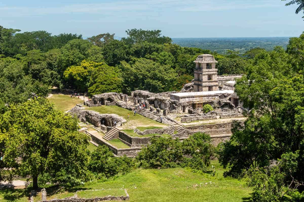
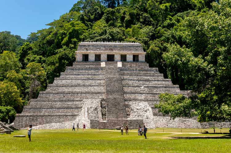
As thicker jungle, higher humidity and Maya facial profiles increased, the archaeological site of Palenque neared. For me, this ranks at the epitome of the Maya World. At the park entrance however, the enchantment seemed veiled. Instead of their previous stoic and unimposing posture, the Lacandon Indians, reportedly the truest Maya, hawked beads and handmade dolls with annoying persistence. Had economic necessity eaten away their shyness?
Inside the park area, the evidence of new realities crumpled my romantic memories of a place whose only sounds had been from the howler monkeys hiding in the trees. Now venders of stone replicas of Palenque treasures littered the site. Stands selling Coca-Cola, what else, dotted the entrance and Mexican trinket sellers invaded our quest to revisit this magnificent Maya place of pyramids.
The trudge down the stairway inside the Temple of Inscriptions to the burial sarcophagus of Pacal, famed Maya ruler here for 60 years, is no longer permitted. We thanked fate that we had enjoyed that privilege on our last excursion.
Persistent October rains pounded the stone walls, but deeper into the site, howler monkeys screeched in the distance, and the magic of Palenque returned. The splendor of this 1500 year old civilization, the Maya as builders, scientists and calligraphers, remained the treasure.
Yaxchilan and Bonampak
A further drive southward, toward the Usamacinta River separating Mexico from Guatemala, brought us to the town of Escudo Jaguar, the principle location for renting canoes for the trip upriver to the eerie and less accessible Maya establishment of Yaxchilan.
Yaxchilan, meaning place of green stone, served the Maya from 200 to 800 A.D. with the greatest period during the reigns of Shield Jaguar I and Bird Jaguar IV, from 742 A.D. until 772A.D.
Reportedly, soil depletion through repeated plantings of maize, forced the inhabitants of this particular Maya site to turn cannibalistic prior to its demise. Nevertheless, the labyrinth of stairways, platforms, passages and chambers constructed during the height of its glory, revealed architectural genius.
After returning to Escudo Jaguar by boat, we drove another hour to Bonampak. Until 5 years ago, an airstrip built and paid for by Singer Sewing Machine magnate, remained the only access to this mystical archaeological beauty. With the completion of the unpaved, one lane, sand packed road, tourism has increased markedly.
Aside from a few outcrop buildings and half pyramids, the draw remains the chamber of painted murals. Contemporary with Palenque and Yaxchilan, the wall paintings were miraculously preserved from the humid elements when the roof collapsed against the walls. When it was raised during restoration, strikingly vivid red and blue dyes depicting the ceremonial life of the Maya emerged.
Once again we managed to beat the “Ticking Time Clock”. We would be among the fortunate few allowed inside the mural’s chambers. Soon, they too would be sealed from public entrance due to overexposure and deterioration. First Pacal’s tomb and now Bonampak’s murals and we managed to witness both. We thanked the Maya gods for this gift before leaving.
Villahermosa and the Olmecs
Coming full circle in the Chiapas, we headed west, toward the Mexican state of Tabasco and its capitol Villahermosa, as our departure city. Here the mouth of the Grijalva River, which connects with the Usamacinta, opens into the Bay of Campeche and the Gulf of Mexico. Our journey began on this same waterway, many days ago near Tuxtla Gutierrez in the Sumidero Canyon.
Villahermosa’s richness as a commerce center, mid-point between Mexico City and Cancun, sprouted further with oil discovery in Tabasco in 1916. We anticipated the much acclaimed Natural History, Open Air Museum at Parque Tomas Garrido Canabal.
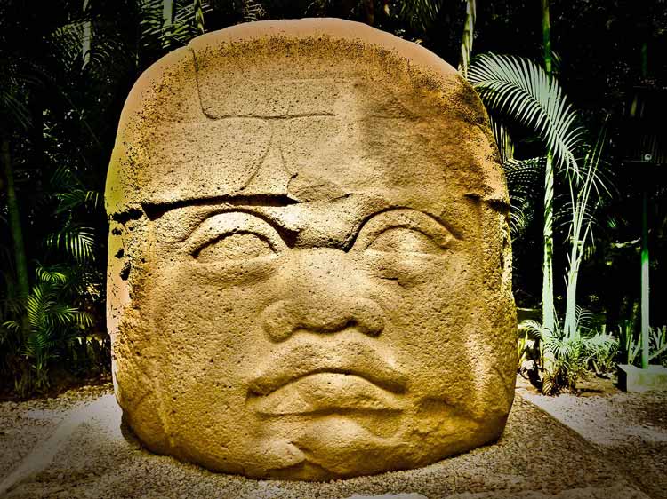
Founded in 1596 by Hernando Cortez, Villahermosa has played an important role in the archaeological treasures of Mexico. Remnants of the Olmec civilization, considered the first organized group to inhabit Mexico and who reigned from 1200 B.C. to about 400 B.C, were discovered in 1938. The Cabeza Olmeca or Olmec Heads remain the most publicized and fascinating aspect of this ancient culture.
Standing over six feet tall, and weighing between six and twenty-five tons each, these colossal heads, likened to half adults and half infants, all sport fleshy lips that turn down, known as ‘The Jaguar Mouth.’ Precursors to the Maya, the Olmecs developed the first glyph script and number system in this hemisphere.
They fashioned these heads from basalt rock without the use of chisels. How they got these mammoth pieces of rock from as far away as sixty miles to their ceremonial and residential sites remains an even bigger mystery, although many anthropologists believe they brought the stone slabs by raft.
Four heads were discovered in the Olmec city of La Venta, 10 in San Lorenzo and three in Tres Zapotes. Wild theories abound, none with factual evidence to support them, as to what these heads represent.
Due to the distinct African facial characteristics, one recurring theory is that the heads were made in honor of the Nubian princes sent westward by Ramses III of Egypt. Whatever the original influence, they make jaws drop.
Due to Pemex’s oil drilling intrusion in 1916 where the heads were found, poet, Carlos Pellicer Camara arranged to have the entire lot of Olmec stela, animal sculpture and colossal heads moved to its present location in 1952. The park, originally founded by Tomas Garrido Canabal in 1930 was totally remodeled in 1985.
The Museo de la Venta section of the park, an open air trail through natural flora fronting the parks’ beautiful lake, Laguna de los Ilusiones, provides the perfect outdoor display for the archaeological pieces of the Olmecs.
We arrived at the park before the heat of the day made it unbearable. Signs on every tree and plant educated the trail walker as to the tropical foliage that existed at the Olmec heads’ original site.
The shade of the tall palms protected us from the overhead sun, but not from the humidity or the buzz of mosquitoes. Our clothes turned wet almost instantly. We dug through the backpack for insect repellant, required carry in the tropics.
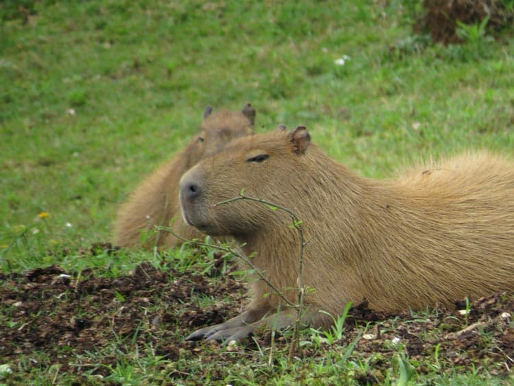
All lathered up, we trudged through the Olmec world. The huge heads hiding among the rushes popped up during our two-hour wander through the winding, lush trail. Small rodent family capybaras, endemic to the area, run wild along the path and evoked a scream from me the first time one crossed.
The outdoor Olmec Museum is only a small part of Tomas Garrido Canabal Park. The Natural History/Anthropological Museum, the Zoo and the Laguna de Ilusiones could provide two full days of exploring. There is even a sound and light show every evening to witness the Olmec sculptures at night. For me, technologies of illumination and sound have no place among archaeological treasures.
As we completed our circle of the Chiapas, we reflected on the contrasts, the paradoxes, the memories we had encountered. From natural wonders, to ancient indigenous cultures, to a jewel sierra city, to a steamy metropolis in the lowlands, we experienced a cornucopia of different kinds of candy for the senses.
2021 Update: The Mexican State of Chiapas currently has seven communities that have remained covid free. The state has maintained a green light in the stop-light classification to determine degrees of lockdowns required to mitigate the disease through Jan. 3, 2021.

- How to Get Around in Sydney: A Local’s Guide to Traveling Around Sydney - April 24, 2024
- The Low-Key Magic of Ghent, Belgium - April 22, 2024
- Discover the Hidden Charm of Extremadura in Spain - April 20, 2024